: 12 MAY 2026, TUESDAY, 16:07:21
The haors lie downstream. Hence, the region is known as Bhati-Bangla—the Bengal of the lowlands. Upstream, to the northeast, rise the hills of India. Meghalaya’s Cherrapunji and Bangladesh’s Sreemangal are among the rainiest places in the region, and the haors sit directly beneath this rain-soaked landscape. When rainwater rushes down from the hills, people here call it the upstream hilly torrent. In the haor’s own vocabulary, the flood created by this sudden rush is Afal. When storms and strong winds whip the haor water into violent waves, they are called Afarmara waves.
Life in Bhati-Bangla was once intimate with the arithmetic of upstream and downstream water. Echoes of that knowledge live in the Mymensingh Gitika and the old Baromasi songs of Sylhet. Water rolled down from the hills and entered the haor below. Its arrival was like the coming of a naiori—a daughter returning to her father’s home. This naiori of water stayed through the monsoon, then left the region through the many rivers and channels, heading to the sea. In that long journey from hill to sea, the haor received the special touch of the Baishakhi waters. That touch carried no blow, no agony, no deceit of sudden submergence. Now, year after year, the haors drown.

During the British colonial period, Robert Lindsay came from Europe to Sylhet to make his fortune. Through influence, favour, and colonial patronage, he ruled Sylhet for twelve years. Yet in Lindsay’s descriptions of downstream Sylhet and northeastern India, there is no sign of haors repeatedly swallowed by hilly torrents. He wrote instead of the deep forests of the haor region.
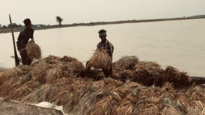
Alongside the beel, kanda, jangal, and hatibandha villages, swamp forests were among the defining features of the haors. The Korocher bag, Hijoler bag, Nol-notar bon, and Ikor-atiyar bon were familiar names in the haor’s own dictionary. Just as the Meghalaya hills were covered with mixed rainforests, the haors had their swamp forests. Those ancient forests have now almost disappeared. Once, the Forest Department even had a dedicated Swamp Forest Office in the haor region. Today, only a few weakened remnants survive: Khortir Jongol and Lokkhi Baor in Baniachong, Habiganj; Ratargul in Sylhet; and Tanguar Haor in Sunamganj.
The story of these lost forests is inseparable from the story of the haors’ submergence and the crisis now taking shape. From the Kalbaishakhi storms of Chaitra and Baishakh onward, rain fell relentlessly over the upstream forests before rolling down toward the lowlands. In those hill forests, dense layers of wild vines, grasses, shrubs, and trees slowed the rainwater, keeping it from rushing directly into the haors below.
Through the forests, rainwater descended from upstream to downstream as if filtered, as if slowly seeped through. The haor people knew the namota of these hilly torrents by heart—their rhythm, timing, and manner of descent. Each haor sits at a different geographical distance from the hills. People could calculate how long it would take the torrent to reach Matian or Kharchar Haor after entering Tanguar Haor. By reading the pattern and arrangement of clouds, elders began preparing for the Afal.

For add